Friday 2 November 2018

Volcanic Reefs of Mission Beach


At Mission Beach are some unique rocky reefs of volcanic origin. Local volcanoes produced a very fluid lava that spread across the landscape in long streams. One of these streams created Clump Point, a finger of land which juts almost a kilometre into the sea. On aerial photos, other lava flows are easily identified including a few that are partially or fully submerged. Old lava flows are also hidden two metres below the tourist trampled white sand of Mission Beach.

Pelicans resting on a lava flow, a few hundred metres from shore
This post looks at a pillow lava reef which was five kilometres out to sea. This rocky reef probably breaks the surface far more than it is submerged. There is no beach and no terrestrial vegetation, only a hectare sized patch of black rocks. It is very hot and not very interesting unless you are a biologist. Even then, you want to study this place properly the first time so that you do not have to come back. Surrounding the reef is a sandy seabed and the margins of the reef have a hedge of sargassum. Coral is not to be seen.

This lava reef is five kilometres from shore

The edge of the old lava flow has sargassum and is surrounded by a sandy bottom
When you stand and stare long enough, you realise that this reef has a rich diversity of algal turf grazers. Fish, crabs and snapping shrimp battle for territories of turf. Blennies would attack and drive off much larger crabs. Crabs with heavy nippers would become frustrated with trying to clip the turf and would push their faces into the turf to chew it off directly. Even snapping shrimps would graze the turf using their larger nippers like shears with long, thin, lightly built arms darting over the surface picking up bits and pieces.

This snapping shrimp was cropping algal turf with the big nipper and picking at it with a skinny green nipper

A common hairy crab - Pilumnus vespertilio


A swimming crab grazing with its mouth

Another type of hairy crab grazing with its nippers
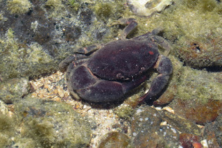
Large, heavily built crabs consume molluscs, both oysters and many gastropods that would normally assume the grazing role. Oysters were limited to exposed edges where water flow would be better and predator access more limited. Only a few neritas and cowries were on the basalt reef.

Ozius truncatus
A black finger crab is able to crush strong sea shells
On a nearby reef trochus shells were present. The nearby reef was a different geology, possibly a contact zone rock which was melted by the lava flow, then re-solidified. Corals also performed much better on this substrate.
Trochus shell in pocket in rocky reef

The underside of the same shell

A rocky reef that is probably contact zone rock, rather than basalt.

Volcanic features such as dykes and cliffs of solidified ash are present on nearby islands and on the mainland. At the bottom of one of these cliffs was a rock shelf which was only just inundated at high tide. On this shelf was a very shallow pool and a few rocks, fallen from the cliff. It was a particularly nasty place, intensely hot and saline. Yet when I looked, most of the stones were surrounded by a wide black halo. I also had the feeling that something was hiding behind one of the stones. I walked around the stone about five times and didn’t see anything but could hear frantic splashing. The only way to find out was to lift and remove the rock. A few crabs ran off but there were several large gobies stranded in a film of water too shallow for them to swim in. Apparently this species chooses to live in this habitat, a tiny area of the very worst aquatic habitat I could find. I love finding exotic creatures in places were nothing should be able to survive.

Dusky Frill Gobies in very shallow water on a rock platform 

The rock I lifted to see the fish

Wider view of platform of compressed volcanic ash


Wednesday 26 September 2018

Mossy Mangroves in the Daintree


Moss does not usually grow on the ground in mangrove swamps. In fact there seems to be only one species of marine moss. Whilst, I lack the expertise to officially identify this moss, I have found mangrove forests in the Daintree, where the forest floor is carpeted with moss.

Mangrove moss, possibly Taxithelium merrillii

Moss-like algae is common in the mangroves but the sporangia show that this is really moss.
The mossy ground is in the back swamps, where the ground level is high and conditions are almost terrestrial. Only the tree species reveal that these areas are of mangrove character and not rainforest. The ground is more soil than mud and crabs are scarce. Buttress roots from Looking glass mangroves meander across the ground for several metres around each tree. Stands of these trees create a ground-level maze for the forest's smaller creatures. Scrub fowl scratch and poke around among the roots. Above in the canopy are giant basket ferns. It is like an alien ecosystem.

Scrub-fowl are as large as roosters and buttress roots are far larger

Some of the buttresses are as high as a man and twist across the forest floor for 10 m.

In peak condition, Looking glass mangroves are one of the tallest species.
This unique mossy habitat is only 50 m wide and perhaps a kilometre long. It is probably only found near the Daintree River although it may also be present in the coastal regions of our wetter northern neighbours.
This band of forest is the only mangrove forest where really large buttresses were the dominant root structure.

Almost a kilometre away, this intriguing stand continued.

Where the stand transitions into mangroves, a thick understorey of mangrove seedlings was present.
Further up the Daintree River is a freshwater mangrove swamp. Even though the water in this area would be fresh enough to drink for most of the year, it is still tidal. During droughts the freshwater dwindles and sometimes these areas are exposed to full seawater. These events are tolerated by the freshwater forests and their fauna. I suspect that the mud is always close to saturation and does not absorb much saltwater. Often the small amount of freshwater that persists also forms a protective film on the surface of the river. One consequence of not having seawater inundation is that the animals that feed on what the tide leaves behind are absent and creek banks are often smooth and almost devoid of crab holes. Only crabs that feed on fallen leaves are present and in very fresh areas, even these are usually absent. The fish are more exciting and I have previously written about the fish that choose to live in these habitats.

Freshwater tidal area with red Sonneratia mangroves and River Cherry trees.

River cherries, Barringtonia mangroves and sedges grow in a tidal forest.

On the river, the breathing roots can be as tall as a man.

Where the surrounding landscape has not been converted to agriculture, these brackish and tidal freshwater reaches are as extensive as the seaward edge of the mangroves. In most areas, only traces of this habitat remain.

Saturday 10 March 2018

Fish spawning in the big wet

The day after the 2018 March deluge stopped, the local stormwater drain was full of fish. Not just any fish but strikingly colourful fish. These fish had come to spawn. They are all native fish that are usually brown, but on this day they were dressed up to impress. Two species were putting on a show, snakehead gudgeons and empire gudgeons. Snakehead gudgeons, not to be confused with Asian snakeheads or fishzilla, are a native Australian fish of mangrove estuaries.

Giurus margaritacea
The females were fat with eggs and males where brightly coloured (click to zoom)
Giurus margaritacea
A pale snakehead with bright ventral fins
The snakeheads gudgeons slowly circled in the main pool with males showing their colour to the females. There were two males and each time one made a move toward the girls, the other would approach and swim beside the first male to make sure that the girls knew he was there too. I did not see any fighting and the boys sometimes followed the girls and vice-versa. It was speed dating in slow motion and eventually the girls decided who was best.

Giurus margaritacea, courting
Two males trying to entice a female to their corner of the pond
Around the edges of the pool were bright red male empire gudgeons. At about 8 cm long, they were so full of confidence, that they were even approaching the 25 cm long snakehead gudgeons, which annoyingly had large patches of red. By the afternoon the empire gudgeons were gone, probably having expended themselves, they had ceased displaying. Their colours would have back to mostly brown although the keep their red head.

Hypseleotris compressa, male in breeding colours
Male empire gudgeon displaying on wall of drain
Surprisingly, the drain was almost empty before the deluge. Only a few rainbow fish (Melanotaenia splendida) had colonised since the wet reestablished a persistent pool at the outlet of the drain. In dry years, the drain can be dry for most of the year. During the wettest years, it can flow for most of the year and can support a diverse freshwater fish community of a dozen species. Being above normal tidal limits, the water within the drain is completely fresh, unless an extreme tide pushes in. Paperbarks and beach hibiscus line the drain and the beach hibiscus have grown long trailing roots into the flowing water, which now form a thick mat that the migrating fish have to negotiate.

Hibiscus tiliaceus creates deep root mats in flowing freshwater
Giurus margaritacea  close-up of head
Female snakehead gudgeon resting in the root mat
The drain is somewhat special. It is near the mouth of a river, so when the juveniles of freshwater fish are flushed out by floods, they often attempt to swim up the drain. Originally, before development, there was supposed to have been a drainage line in much the same position. Small creeks and drainage lines would once have been common but now have been replaced by farm drains and urban drains. There are not many small intact waterways which flow during the wet but dry out and prevent common freshwater fish such as guppies, tilapia and even native jungle perch from dominating the ecosystem. Perhaps this explains the desire for the gudgeons to breed in this waterway. 

Pool where water leaves concrete drain
stilt mangroves
25 metres below where the drain emerges,the freshwater flow fans out in a mangrove swamp
In the late afternoon, I decided to put my underwater compact camera on a pole and push it below the surface to see if I could get some close up photos. As I can’t clearly see what the camera is shooting, I use video, then create stills from the video. It was almost unbelievable, what the camera recorded. The fish were in the process of spawning when videoed.


The next day, I went back to try and get some new shots and the fish were largely gone. Only two or three snakehead gudgeon were present and they were much more wary of people and darted for cover. Males of both species were loitering and hoping for late females, but had lost most of their colour and enthusiasm. They only consolation was that I was able to photograph the very tiny eggs (white specs) that had been glued on dead wood the day before. The video clip shows these very eggs being deposited.  Firstly the female glues them to something with the pink appendage and then the male fertilises them (not visible in this clip) using a similar pink appendage.


Giurus margaritacea
Tiny white eggs deposited on a stick
Whilst I have called the fish snakehead gudgeons, I am not totally sure as they were identified using photos from the net. Usually, spangled gudgeons (Ophiocara porocephala) are the main local species and are of similar size and shape. So few photos of the fish in their breeding colours are on the net, that positive identification is difficult. Usually, it is best to review several sources, particularly authoritative sources before labeling species.

Spangled gudgeon usually hunt around this area.

Monday 26 February 2018

When the Great Barrier Reef was a land of hills and trees

There is a great deal of academic research being conducted into how and when Aboriginal people arrived in Australia. The one be assumption is that people arrived when sea levels were at their lowest, to as much as 130 m below present levels during glacial periods. Lower sea levels reduced the gaps between land masses and are thought to have made island hopping much easier. At these times, all of the coral reefs we know today would have been on land. The Great Barrier Reef was a chain of limestone hills. All of this was only 10000 years ago. This transformation between terrestrial ecosystem into marine fires the imagination. What would it have been like to wander in a landscape where coral reefs were hills? There places on earth where it is possible to do so today. One of those places is the coast of Papua New Guinea. 

Diagram from Sceptical Sciences
On the southern coast of PNG, at a place called Bluff, which is in Gulf Province near Kerema there are a few uplifted coral reefs which are morphologically similar to the reefs of the present day Great Barrier Reef.  The headland of Bluff is one such old coral reef. It is formed of dense coral rock where the detail of the polyps has been lost. Caverns run through the headland.

This headland has a legend about a battle between a hunter and boar.
One of the caverns which face the sea and are partially filled at high tide

Not much detail in the rock, mainly live embedded sea anemones

To the north of Bluff is a low linear plateau with coral reef and rubble slopes on its southern end. Gulf Province is a land of large rivers that pump out stupendous quantities of sand and mud and looking now, I think the plateau is formed mainly from mud stone or argillite with a veneer of coral.

Waterfall from top of plateau, which is only about 20 m high.
Gulf Province has about 9 m of rain each year and the land is sparsely settled area of swamps and heavy jungle. The plateau is the only raised land for several kilometres. No-one lived there although springs on the side of the hill did provide drinking water for local villagers. 

Waterfront at Kerema 2012, plateau visible in background
The southern end of the plateau has sides covered with coral rubble which often has well preserved polyps. 

Coral colonies are clear visible
Coral rubble from beside drinking water spring
Ancient coral colonies become boulders on the beach.
On the western face of the plateau are some small caves and grottos. After squeezing into one grotto, I found that I was less than a metre from a rather deadly looking snake. I later identified it as a viper boa and not a viper. Viper boas are a type of boa, like a python but as they have live young are a boa and not a python. 

Entrance to a grotto which opens up inside
A viper boa was inside (Candoia aspera)

Also in caves were enormous cave crickets. They were lined up on the ledges and scurried around when I got close.


The limestone nature of the hills was clear from the cave features such as shawls that were developing in larger caverns.


Wednesday 14 February 2018

Wildlife of Clairview and St Lawrence

Clairview and St Lawrence are important habitats for larger creatures such as koalas, greater gliders, possums, goannas, emus and a wide variety of wallabies but these creatures are not easy to find. The area is on the threshold for many wildlife species and they occur only in the better pockets of land or at low densities. It is easier to find smaller creatures that can live in smaller patches habitat. Wetlands and watercourses are where the action is.

Roadside tree with koala and possum scratches (click to zoom in)

A brushtail possum in BarraCrab Caravan Park
At Clairview, at the southern end of the beach past the caravan park is a tidal creek with large colonies of fiddler crabs on the adjacent flats about 100 m out from the beach. There are two main species, a large species with hot pink nippers and green backs and a small species with a grey-white nipper. The smaller species makes up for lack of colour by waving so frantically that the crabs sometimes bounce across the ground. It is a great place for kids to discover a few wild creatures and perhaps even catch some. 

Fiddler crab colonies are on side opposite this large mangrove
Uca seismella - little white bouncing fiddler crabs are on the lower bank
Two-tone fiddler crabs (U. vomeris) and smaller pink fiddler crabs

Pink fiddler crab - Uca polita
Near the mangroves are red climber crabs (Metapograpsus frontalis)
Male fiddler crabs have one large nipper for demonstrating their power and a tiny nipper for feeding. Very rarely a crab will have two large nippers. Finding one of these is the Queensland equivalent of finding a four leaf clover and I found one at Clairview. In forty years, I have only seen four such crabs.

The fiddler crabs that dominates the banks of St Lawrence Creek are a different species, one which prefers salt pans to the intertidal mud flats. 

Uca signata (click to enlarge)
If you are lucky to be present when the tide is rising and filling the creek out from the beach, you may see popeye mullet. These strange fish swim with the eyes above water so that they can see predatory birds. The lower part of their eye has differently shaped optics so that they can see underwater. If the tide is out, the bottom of the creek is filled with fine soft silt that perfectly records the prints of a multitude of mostly unseen creatures including sea turtles, gropers, giant mud skippers, mud crabs and much more. Working out which creatures made which prints can be a challenge.

Pop-eye mullet in St Lawrence Creek
Unfortunately, the popeye mullet are not reliably present and chances of seeing these strange fish are better in St Lawrence Creek, which flows past the town of St Lawrence and is about 20 km from Clairview. Clairview is an old volcanic area and has low hills of volcanic origin, whereas St Lawrence is located in an ancient coal basin, filled with deep sediments. Despite their spatial proximity Clairview and St Lawrence are in different bioregions, which are the ecological equivalent of countries. The climate, landforms and geology differ enough that different groups of species dominate. At Clairview the eucalypts have green foliage and close to St Lawrence the foliage is usually grey. The boundary is diffuse being about 10 km wide and there is no sudden change. 

Colour of ironbark leaves near St Lawrence
Coal basins are full of fine mobile sediments. St Lawrence Creek is more like liquid mud that water and it is no wonder that popeye mullet with there ability to look above the water to see where they are are so abundant. Another fish that revels in liquid mud is the blue mud hopper, which is a relative of the mud skipper. This muddy world is alien and worthy of a visit. 

Small mudskipper (left) and a blue mudhopper (right)
In only 8 km, St Lawrence Creek which becomes tidal at the highway, increases from a few metres wide to approximately 500 m wide and with 8 m tides, has swirling waters and standing waves caused by racing tides. The Styx River, which is only 20 km away has tidal bore, a wave up to 1 m high caused by the rush of the incoming tide. Unfortunately this river is inaccessible and it is quite possible St Lawrence Creek also has dramatic incoming tides. Only some tides have strong bores but these are predictable. Perhaps the combination of soft ground and violent tides creates these strange creeks which are a metre wider for every ten metres downstream. 

St Lawrence Creek just beside Bruce Highway is about 10 m wide
St Lawrence Creek is 500 m wide, only 8 km downstream
St Lawrence is famous for wetlands and waterbirds. The small seasonal creeks also have their own fauna which is adapted to floods and droughts. However, it is the marine environment that interests me. I want to see and understand the biodiversity of the muddy waters, a largely ignored scientific frontier.

Where pipes run under the highway, there are often moulted crab shells


A freshwater crab caught in a drain beside the highway
See also: Postcard from Clairview